


Naksha is a citizen-led initiative to assess how pedestrian-friendly Mumbai’s streets truly are. With nearly 47% of daily commutes involving walking—especially for last-mile connectivity—safe and accessible footpaths are critical.
Starting with the cultural mapping of South Mumbai’s heritage roads, the project uncovered glaring walkability issues even around iconic sites like the Gateway of India and Kalbadevi Road. Encroachments, broken footpaths, and lack of crossings are just some of the challenges faced daily by pedestrians.
Guided by Indian Road Congress (IRC) standards, Naksha is now mapping roads in Mumbai to build a data-driven foundation for city-wide improvements.
We invite corporate teams to participate in this impactful initiative as a meaningful volunteering activity. Help us create safer, more inclusive streets for all.
To join or learn more, email us at volunteer@projectmumbai.org.
Project Mumbai has launched one of the biggest and largest mapping initiatives of Mumbai’s roads. And what is on these roads. Including Hospitals, Educational institutions, pharmacies, and even Police stations. A collaborative action plan aims at ensuring every main road, every ‘gully’ gets mapped and its history recorded. A QR Code will help you navigate this further.
The MCGM, the Mumbai Police and the Mumbai University have joined hands with Project Mumbai to make this happen.
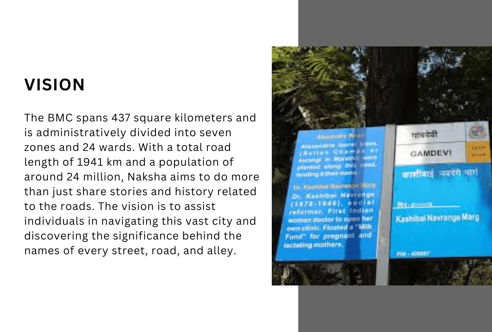
Project Mumbai’s initiative is to first identify every road, source the history of the person of prominence who is featured on the sign board, and feature their contribution on a digital platform.
Additionally, the effort will be to provide details of other civic requirements of importance, which are the police station locations, addresses, numbers, and subsequently hospitals, educational institutions etc, on the map.
The next is to QR code the sign boards which will be the enabler for citizens to be able to digitally track the locations with ease.
And lastly, but most critically, ensure that the locations are all geo-tagged so that every citizen can not only benefit from the location, but also the points of interest at the click of a button.
Another interesting aspect that the Project Mumbai team plans to add is that every time a person clicks on the road sign and name, he/she will get to see which police station or jurisdiction this road comes under, which will be a huge enabler for citizens when they have to report a crime or any untoward incident.
The Mumbai Police has agreed to map and share locations of every police chowki and police station across the 94 police stations under Municipal limit, with their contact number etc, with Project Mumbai.
The Mumbai University has officially joined hands with Project Mumbai by offering us an army of 15,000 student volunteers for the data collection exercise.
One of the most prominent and credible history institutions of India has offered its historians to support the process of verification of data. The association will get formalised soon.
Several other student groups have joined hands to help research and authenticate the data that is being sourced.
The entire collaborative initiative is being led by Project Mumbai.
Project Mumbai Design by Viral Inbound
Copyright © 2021. managed by WebGyor Technologies
With an impact graph stretching across three decades, Shishir has ventured into several interconnected arenas of work each of them as exciting as the other, if not more. At the heart of Shishir’s core and vision, are not-for-profit campaigns and initiatives which help citizens achieve transformative change by engaging with systems and structures. Citizen empowerment and a qualitative change in their lives for the positive, is what he strives towards – in action and as a catalyst.
Up until November 2017, Shishir was the CEO of Bombay First, also known as Mumbai First, a unique not-for-profit model of Public-Private Participation which aims at making Mumbai a better place to live, work and play, for everyone. As it’s youngest CEO, he held the position for close to four years. During his stint at Mumbai First, he was instrumental in setting up the much-appreciated War-Room for the Government of Maharashtra, to fast-track key infra initiatives. It was a Mumbai First-McKinsey initiative with the Government of Maharashtra.
In 2017, iVolunteer, an international not-for-profit body awarded him the Special Jury Prize, as an acknowledgement of his ‘Exemplary contribution to India’s Social Development.’ Another one of his initiatives, Vote4Mumbai, along with the State Election Commission, Maharashtra, played an important role in corporate citizens stepping out to vote in larger numbers, resulting in a 10 per cent rise in voter turnouts for the civic elections of Mumbai two years ago. His effort was acknowledged officially.
He also led a 25000-strong volunteer base of citizens to beautify 36 Railway Stations of Mumbai, within a record seven days in 2016. This is arguably one of the largest such volunteer-focused public private people initiatives to have ever unfolded in India, in such a short time.
Chairman of Muskaan – Sharing Smiles, a not for profit engaged in educating under privileged children in one of Mumbai’s suburbs and also a Trained Counsellor, Shishir takes up Individual and Corporate Counselling projects on request. He was part of the founding team which set up Nithya Sahaya, a first of its kind free, walk-in counselling at St. Michael’s Church in Mahim, which experiences a foot-fall of over 90,000 people every Wednesday, across faith, gender and economic strata.
Shishir is a lawyer, with a postgraduation in Mass Communication. Associated with some of the best institutions, including NDTV, Aaj Tak, MidDay and Indian Express, he was regarded as a hard-nosed journalist and anchor, during his 20-year stint as a journalist.
His passion for facilitating collaborations at multiple levels, across various verticals and ability to hone better leadership and ownership in individuals as well as organisations, makes him an asset to the development of a city like Mumbai and an icon for socio-civic changemakers.
Spent over 2 decades in various capacities including being responsible for Supply Chain and Chemicals business and spearheading the Human Resources, Corporate Quality, and Safety Functions at the group level at Asian Paints, amongst the top ten paint companies in the world with a manufacturing presence in 16 countries. Led the international business and was the chief architect of the blistering expansion in international markets through organic and inorganic growth. Chairman, Board of Governors for Indian Institute of Management (Tiruchirapalli, Tamil Nadu).
Current Board positions of Corporations: Independent Director on the Board of HDFC Ltd (Listed on the Bombay and National Stock Exchange) and Havells India (Listed on the Bombay Stock Exchange); Board Member on Addverb Technologies Limited, a start-up technology company.
Current Board positions on Foundations: Additional Director on Board of Reliance Foundation; Board member of Piramal Foundation and Piramal Foundation for Education Leadership; Tribhuvandas Foundation and Trustee of Sir H N Hospital; Vice President of Kapadwanj Kelavani Mandal (Trust based in Gujarat).
Current Board/member positions on Government bodies: Board member of National Skill Development Agency (NSDA); Member of Pradhan Mantri Kaushalya Vikas Yojana (PMKVY) Steering Committee.
Current position in Industry Chambers: Board of Sportscom, National Council member (CII), Co-Chairman of National Committee on Sports (CII); National Executive Committee member (FICCI), Member of Sports, Physical Education, Fitness and Leisure Skills Council (SPEFLSC).
A Chartered Accountant by training, a Banker by profession, and a perfectionist by nature. I believe that the purpose of life is to make it better …better than what it was yesterday, for oneself, one’s family, and for the community. I have two guiding philosophies, 1) ‘there must be a better way’ and 2) ‘no harm in trying.’
I grew up in Delhi and flew the nest when I joined HSBC Bank. Since then, my life is landmarked by the seven cities I have lived in across different parts of the world. I started my working life with A.F. Ferguson as, Consultant, and thereafter I joined Hongkong Bank (now HSBC Bank). My work experience has been mostly in traditional banking operations and corporate banking. I worked for HSBC Bank in Hongkong, Delhi, Mumbai, Kolkata, and Dubai.
As I became a trailing spouse, I got the opportunity to work in different organizations; Mashreq Bank in Dubai where I worked in Corporate Banking and IFC-SEDF (South Asia Development Fund) in Dhaka, where we worked in partnership with the government, the private sector, donor partners and other development partners to deal with the constraints to SME development in Bangladesh. Currently, I act as an advisor to aspirants, whether they are aspiring college entrants or budding entrepreneurs.
Manish has over 25 years of experience in Infrastructure and has been a sector leader at Crisil, KPMG, and PwC. He has advised Investors and the Government in enabling private sector participation in infrastructure. He is now an independent expert on Sustainability & Infrastructure Financing; and writes on public policy issues at www.askhowindia.org.
Besides being on the Advisory Board of Project Mumbai, he also Chairs the Rurbanisation COE of Jagriti Enterprise Center – Purvanchal. He is BE(Hons) from BITS Pilani and PGDBM from IIM Calcutta.
Ridham Desai is a Managing Director of Morgan Stanley with 20 years at the firm. He heads Morgan Stanley’s Indian Equity Research team which is the top-ranked team in the country. He is the country’s top-ranked equity market strategist and has been consistently ranked among the best analysts in the country over his career spanning over 26 years. He has represented Morgan Stanley in several public debates on the equity market and the economy and is also a regular media contributor. He has led debates on the Indian economy since the beginning of the 90s penning several path-breaking reports on the country. The latest such report is India’s Digital Leap: The Multi-Trillion Dollar Opportunity which discusses how the digitization of the country over the past three years is taking the country into a new growth orbit and how India could be the best investment destination in the world in the coming years.
Paresh Sukthankar is the Lead Partner of Sanaksh Advisors LLP, a firm he set up in 2019 to provide business and management advisory services, primarily to Private Equity and Venture Capital firms.
He is an independent non-executive Director on the Board of Commercial International Bank (Egypt) and is an Advisory Board Member at Yuva Parivartan, Kherwadi Social Welfare Association. Mr. Sukthankar is a member of the Board of Management of the autonomous Jamnalal Bajaj Institute of Management Studies (JBIMS) and on the Board of Research of the University of Mumbai.
He is also a member of the Academic Advisory Council of the College of Supervisors, Reserve Bank of India, and a Mentor to the Indian School of Democracy.
Sukthankar has been a banker for over three decades. He was part of the core team that founded HDFC Bank in 1994-95 and helped build it into one of India’s leading, most respected financial institutions. He was inducted on the bank’s Board as Executive Director in 2007 and elevated to the post of Deputy Managing Director in 2014.
He tendered his resignation in August 2018 and completed his tenure with the bank in November 2018. Mr. Sukthankar has been a member of various committees formed by the Reserve Bank of India and the Indian Banks’ Association. Prior to joining HDFC Bank, he worked at Citibank for 9 years from 1985 to 1994.
Mr. Sukthankar is a Commerce graduate from Sydenham College, University of Mumbai, and an MBA from Jamnalal Bajaj Institute of Management Studies (JBIMS, Mumbai). He has also completed the Advanced Management Program (AMP) at Harvard Business School.
Venkat graduated from IIMA, worked first at “The Times of India” in various corporate and brand management functions, and then joined the founding team of Sony Entertainment Television in India. In 1996, he co-founded Eklavya School, Ahmedabad. He later co-founded Educational Initiatives Pvt. Ltd, a company that works on improving the quality of school education in India. Venkat set up GiveIndia in 2000, to create a “giving culture” in India. In 2009, he, along with several other volunteers, conceptualized and launched DaanUtsav, a festival that aims to bring India together to celebrate giving. Held from October 2-8 every year, the “festival” is a platform that allows everyone from India’s poor to its wealthiest to give back to society.
Venkat is a signatory to #LivingMyPromise, an initiative where middle-class Indians promise to donate 50+% of their wealth to causes of their choice. He has recently been involved in an initiative called #EveryIndianVolunteering that aspires to engage every Indian in volunteering for social causes. He spends 90+% of his time and wealth promoting philanthropy and volunteerism in India.
Graduated with a B.A. in Literary and Cultural Studies from FLAME University. Aarya is happy to work in a place that lets her use what she has learned in college. She likes calling herself a pop culture fanatic and bibliophile who is happy to spend her days doing what she loves: researching and writing about her home city of Mumbai.
Shreya is a Counselling Psychologist and holds a Masters with specialization in Clinical Psychology. She is trained in CBT-REBT & has an Humanistic focussed eclectic approach. Mental Health and Mental Health advocacy are some things she has always been extremely passionate about & she hopes to make a difference in the Mental Health community by reducing the stigma surrounding Mental Health conditions. As a professional she tries to elevate the standards of Mental Health services being provided by making them accessible to all.
Neha Kathuria is a Counselling Psychologist and Dance Movement therapy practitioner
She has been working in the field of Mental health as a practitioner for the last 8 years. Her aim is to make and create a mental health-friendly space where everyone can share their unique and remarkable stories which have shaped their behaviors and experiences. She works from a humanistic approach and believes that each one has the potential to grow and empower. In order to impact a larger audience and bring in change at a larger level, She has joined Project Mumbai as a Project Head/Lead (Mental Health division). She along with her team strives to make a positive change in people’s life by empowering them at a young age itself to make a healthy and happy world both mentally and physically.
Sanhita is a civil engineer with a master’s degree in structural engineering. After working in the energy sector for 2 years, She started her journey with Project Mumbai as a volunteer during covid lockdowns times. She aspires to work towards waste management, low carbon emission and sustainability. She believes that everybody can contribute in making our environment and our society, a better place to live.
Radhika (she/her) is a Counselling Psychologist based in Mumbai. With her love for the arts and passion for Mental Health, she has trained in Expressive Arts Therapy and Dance
Movement Therapy. As a Mental Health Professional she has worked with children, adolescents, young adults on the Autism spectrum, corporate employees, and People with
Parkinsons and their caregivers as well.
She views mental health concerns as those that are created through multiple causes and conditions existing in and around the individual. Therefore, “the problem is the problem, the
person is not the problem”. She facilitates mental health journeys for individuals and groups while also advocating for better environmental conditions for the same.
Her practice believes in the unique experience, needs, and healing potential that resides within each individual. She plays the role of a facilitator to walk with you as you begin to know and
understand yourself better, this unique potential, and are able to live more fully than before.
The President of Forum for Autism, a parent support group, Ms. Parul Kumtha is also a counsellor at Ummeed Child Development Centre and Adult Support Kendra.
She has a Bachelor’s Degree in Architecture (with Honours) from the University of Mumbai. She has diversified her qualifications by studying Conservation of Biodiversity at the Bombay Natural History Society and Built Heritage Conservation Studies with the Mumbai Metropolitan Region-Heritage Conservation Society.
If there is anyone in Mumbai who is a stalwart in the advocacy for special needs, it is Parul. She comes with strong experience in advocacy, parent and family support and school outreach.
Vineet Saraiwala is the Founder & CEO of Atypical Advantage, India’s largest Inclusive Platform to generate economic livelihood for Persons with disabilities.
He did his Post Graduation (PGP) from IIM Bangalore (IIMB) & prior was responsible for making shopping accessible for millions of Persons with disability in India with the Future Group.
He travels alone on the Generosity of Strangers, Treks, Cycles & Runs in high places of Ladakh. He is a lifelong volunteer & believes that a generation of compassion is the only way to make the world a better place.
Amar Jain is a corporate lawyer who has worked in various areas as part of his professional engagement. These areas include Contract Management, which involves compliance, identification of risks and issues, deliverables and obligations, review of statement of works, master services agreements, among others. He has also worked in Indian and international capital markets, which encompass Initial Public Offers, Qualified Institutions Placements, Rights Issues, Bulk and Block deals, Corporate Advisory, and global depository receipts.
Additionally, he has experience in Banking & Finance, which includes External Commercial Borrowings, Foreign Currency Denominated Bonds, rupee and foreign currency term loans, and letter of credits. Amar has worked with law firms Trilegal and Cyril Amarchand Mangaldas, respectively, and Accenture India.
In addition to his legal expertise, Amar is a Certified Professional in Web Accessibility. This certification, obtained from the International Association of Accessibility Professionals, is held by only around 219 people worldwide as of November 2019. It enables Amar to provide consultancy and training on making websites and apps accessible for everyone, including persons with disabilities.
Amar himself has blindness as defined under the Rights of Persons With Disabilities Act, 2016. Despite this, he has received several awards for his work. These include the NCPEDP Mphasis Javed Abidi Public Policy Award by the National Centre For Promotion of Employment of People With Disabilities and Mphasis Limited, for his work in the area of public policy. He also received the Sarojini Trilok Nath national award for best role model from the National Association for the Blind in Delhi.
Govind Iyer retired as a Partner at Egon Zehnder, a Global leadership advisory Firm. Prior to joining Egon Zehnder, Govind worked at Proctor & Gamble, Coca-Cola, and Heinz.
Govind is currently an Independent Director of Infosys Limited & also an advisor to Warburg Pincus India.
Govind has served on the Wharton Executive Education Advisory Board and is an active University of Pennsylvania alumnus. He has served on the Advisory Board of Asian Venture Philanthropy Network (AVPN).
Govind is a founding board member and Chairperson of Social Venture Partners (SVP) India, is a board member at GIVE India, an advisory Board member of The Convergence Foundation (TCF) and is a #LivingMyPromise signatory.
Govind has a Bachelor of Engineering degree from Regional Engineering College, Trichy, and an MBA from The Wharton School, University of Pennsylvania.
Dinesh Mali is a Professional Social Worker, associated with Project Mumbai as a Volunteer Lead.He has worked as a Political Consultant in Punjab and Gujarat Assembly Election. He has joined Project Mumbai with the vision to make happy Volunteers as well as provide good Volunteering Opportunities to each and everyone especially for Mumbaikars. He believes in Action Takers,who are Real Change Makers.
Rupali Vaidya is an Urban and Regional Planner and has been working in the sector of urban development planning ,infrastructure and governance with various government and non-governmental organizations more than a decade. Her expertise lies in comprehensive development plans, Land Use Planning, infrastructure and urban policy.
She have been working as a consultant with government and semi government agencies on infrastructure & redevelopment projects for slum rehabilitation and housing for urban poor in Gujarat and Maharashtra.
She was a faculty in urban planning with CEPT university and BVM Navi Mumbai teaching research methodology and urban design and development projects
Past 7 years have worked with social and urban development projects pan India for habitat improvement projects. Focusing on environment sustainability in urban communities with 360 degree approach to involving citizens in better physical environment.
My key interest lies in research and development activity for an equitable and sustainable approach for better living environment in urban communities.
Passionate about making a difference through social work and creativity! I’m a young and enthusiastic art and design student who loves exploring the intersections of art, design, and social causes. As a content and social media enthusiast, I enjoy using my skills to create engaging and impactful content that connects people within meaningful communities.
Isha is a counseling psychologist, and in her rewarding journey of working alongside a diverse spectrum of individuals, she has learned that each interaction adds a layer of depth to her understanding, enabling her to have a more eclectic, tailored, and empathetic approach towards her clients. Embracing the distinctiveness of each person’s story, she finds great delight in fostering understanding and resilience within our multicultural community.
At the heart of her practice lies a steadfast belief in making mental health services accessible to all. She is committed to breaking down barriers and ensuring that psychological support is available to all, regardless of background or circumstances.
Anindya is a project intern with the mental health division. With her BA in Liberal Arts and a specialization in Psychology, Anindya is committed to understanding how she can create better outcomes for various groups with respect to their mental health. She aspires to become a psychologist in the future & is constantly trying to upgrade her skills and knowledge.
With a B.A. in Political Science, Saachi is a public policy enthusiast with an aim of working in the social sector. She also has a keen interest in the evolution of culture and society in India. She has been simultaneously working towards reducing plastic usage and developing a sustainable lifestyle. Saachi believes that good organization is the key to achieving any outcome. She is always in the pursuit of learning new languages to connect.
Sannya Singla is a hardworking student pursuing a Bachelor’s degree in Psychology at Christ University in Bangalore. She’s dedicated to creating a safe and inclusive environment for everyone around her. Sannya aspires to become a clinical psychologist, aiming to break down the barriers and stereotypes surrounding mental health. She’s a kind and empathetic person who genuinely enjoys listening to others and helping them in any way she can. Her goal is to make a positive difference in society by promoting mental well-being and understanding.
With an M.A. in Philosophy and a deep interest in culture and art, Valenie is very happy to work as a project Officer – Digital outreach and Communication with Project Mumbai. It allows her to share her love for #aaplimumbai and the stories that surround it. Passionate about our city Mumbai, it has always interested her to know something new about it and work for a city she calls home. She loves conversations over chai or even listening to passerby tales. The City holds her heart and she can spend hours in its abyss.
Aditya has completed his degree in BAMMC. He has worked as an intern in Project Mumbai on the Vasind Plastic Recyclothon project for 6 Months in 2022. Currently, he is working as a Fellow at Project Mumbai. He wants to be a part of social change in Mumbai City while working on Environmental Projects. He looks forward to making the city clean and more liveable by spreading awareness about taking care of the surroundings and nature. He is also a Theatre Artist and wants to reach out to more people to solve societal problems through his creativity.
Palak holds a post-graduation degree in Masters in Counseling Psychology from SNDT University. She works as a Project Officer – Mental Health Team as her keen interest lies in Mental health and Arts-Based Therapy. She likes to explore beyond her limits, passionate about learning and gaining experience.
Vaishnavi has completed her Master’s from Central University of Kerala in International Relations and Politics. She is the Volunteer Coordinator for Project Mumbai. Helping to interact, arrange, coordinate, and complete all the initiatives of Project Mumbai smoothly is her goal. She believes that what you sow, you shall reap policy. One bold step to protect our environment can change the lives of so many including our own family. When one comes forward, many will.
Siddesh has joined Project Mumbai as a Fellow. He has worked on projects like Harita, Plastic Recyclothon and also worked as a Railway volunteer. He is currently working on the environment project. Joining Project Mumbai Organization has been an exciting and fulfilling experience for him. Working with Project Mumbai has not only allowed Siddesh to grow professionally but has also enriched his sense of purpose and commitment to social welfare. He looks forward to the continued journey of creating a lasting, meaningful impact with Project Mumbai.
Graduated with Bcom, Pratiksha works as an admin and accountant at Project Mumbai. Her responsibilities include managing day to day operations of the NGO and handling administrative tasks. Also responsible for managing financial records, reconciling accounts, and preparing financial statements. She ensures a smooth workflow by supporting the team with various administrative needs and also the financial health of the organization by budgeting, expense tracking, and tax compliance.
Dr Kersi Chavda has been the past president of the bombay Psychiatry Society consultant at the PD Hinduja National, Hinduja Healthcare and the Sir HNReliance foundation hospitals. He was also the chairperson of the task force for the Indian Psychiatric society (IPS) dealing with school psychiatry and counselling.
Dr Kersi been a active panel member of the task force of the IPS dealing with ethical boundaries between client. This is now being taken up by the IMC as a guideline across Indian health services. While he was the chairperson of the task force of the IPS dealing with the LGBTQ community he lead a team that managed to issue a position statement that was quoted in the landmark judgement by two of the five learned judges when they repealed Section 377. Under his wide horizon he has also been a active panel member of the IPS task force that laid down clinical guidelines for the treatment of Autism Spectrum Disorders. He has been a onfront membe of the Indian Association of Private Psychiatry that dealt with college psychiatry. Dr. Kersi Chavda currently is the advisor of the IPS subcommittee dealing with Mass Media. With an experience of over 35 years Dr Chavda has been working for the interest children. Dr. Chavda has also been awarded the prestigiour Dr SN Lulla oration award and has written a chapter in four books when he was a part of the first panel of the Maharashtra government that had laid down concessions for Learning Disabilities in Mumbai.
My key interest lies in research and development activity for an equitable and sustainable approach for better living environment in urban communities.
Arati leads Volunteering and Corporate Partnership at Project Mumbai. She has an experience of 7 years in the development sector particularly in the field of Volunteering.
Her expertise lies in building and planning volunteering engagements and partnerships with Corporate organizations, Colleges and Groups. Her key interest lies in research and development activities for an equitable and sustainable approach to creating a better living environment in urban communities.
Amey leads the Communication and Marketing Team at Project Mumbai. He holds a degree in BCom; however, he switched his focus to Digital Marketing and the Social Sector, combining his passion for content creation and volunteering.
When not in front of his laptop, you’ll find Amey strolling around the city, recording music videos, taking pictures, and capturing memories one moment at a time.
“Dr. Mona Gajre is a renowed Pediatric Neurologist & Developmental Disorders specialist in Mumbai, having an experience of over 25 years. She is a fulll time Professor of Pediatrics, at the renowed LTMMC & GH, Sion Mumbai. She is a visiting Pediatric Neurologist & Developmental Disorders Specialist at various reputed Private Hospitals & Clinics.
Since 2014, Dr Gajre has been a University approved Mentor for crepitated Fellowships courses in Pediatric Neurology & Epilepsy as well as fellowship course on LD & Developmental Disorders. She has presented various papers and have numerous publications to her name. She on the advisory Committee of various associations working towards child/ adolescent
physical and mental health.”
“Tanmay has completed his Masters in Environmental Science. He has joined Project Mumbai as a Project Officer in the Environment vertical. His love for Mumbai motivates him to work with greater enthusiasm for the betterment of the city. In addition to his work in the environmental sector, Tanmay also enjoys playing football and cricket.“
Sanjay is passionate in helping others and doing philanthropic work, which he has been actively pursuing at a personal level. He firmly believes in imparting training in the subjects that can teach, and play a pivotal role in ensuring that people receive education and good job opportunities. His aim is to help people stand on their own feet and uplift their families socially, making a difference in at least one person’s life each year.
He has also been actively involved in helping blind persons in whatever way he can. Recognizing the need to make a larger impact and give back to society in an organized manner, he joined hands with Shishir Joshi in 2018 and formed PROJECT MUMBAI. The project is aimed at making a positive impact on a larger population.
Shahana leads the Mental Health vertical at Project Mumbai. She is a counselling psychologist and psychotherapist with a master’s degree in Developmental Counselling. With over 12 years of dedicated experience in psychotherapy, she specializes in community-based interventions,corporate wellness,and one-on-one counselling.
She has developed and delivered various self-development programs for vulnerable communities. Additionally, she has designed and conducted impactful mental and emotional well-being sessions, along with leadership training, for well-known Fortune 500 companies in the finance, FMCG, and pharmaceutical sectors to promote mentally healthy workplaces. She has experience of working with esteemed corporate clients as well as reputable educational institutions. She passionately advocates for mental health equity and has a vision of creating a meaningful impact in society.
Saloni Kumawat is an architect and urban planner with a focus on creating thriving and people-centric communities. With 3 years of experience working with development authorities, she brings expertise in land use planning, research, urban policy and infrastructure development.
Saloni believes that the true measure of a successful city isn’t just its infrastructure or development level, but the happiness and well-being of its residents. When she’s not working, you’ll find her relaxing on a beach, watching the sunset and observing people. Her goal is to make a positive difference in society and raise awareness about our responsibility towards the planet.
Bindu leads the HR team at Project Mumbai. With over 28 years of experience in the field she ensures that each member of our team feels valued, heard, and empowered to do their best work. From fostering a positive work environment to providing resources for professional development, Bindu has been committed to success and well-being at the Project Mumbai office.
That morning, in just 10 minutes, over 150 kg of plastic waste was collected from Juhu Beach by the dedicated volunteers alongside AB de Villiers. Demonstrating his commitment, AB de Villiers then travelled from Juhu to Powai to promote The Mumbai Plastic Recyclothon with the Project Mumbai team, accompanied by Additional Commissioner of BMC, Sudhakar Shinde. The day continued with a splash of paint on recycled benches made from plastic waste, which otherwise would have ended up in landfills.
Driving around town with the cricket star, it was evident that his dedication extended beyond the day’s events. AB de Villiers pledged his ongoing support to Project Mumbai and other community causes as part of his Corporate Social Responsibility (CSR). He expressed profound admiration for the volunteers, calling them the real heroes and emphasizing that their efforts to keep the city green and clean were a source of his inspiration.
“If AB de Villiers can, so can we,” he urged. Embracing the motto, “Mumbai Ke Liye Kuchh Bhi Karega,” Mr. 360 encouraged the citizens to dedicate some time for their city. Stay tuned for more updates on this inspiring journey.